
Why did an Augustana GIS class learn to fly?
Her official licensed Federal Aviation Administration (FAA) commercial drone pilot’s card had just arrived, and Amanda Walljasper ’23 was excited. “I was really nervous,” she said about the certification test, “and most of the questions on that test are for actual pilots.”
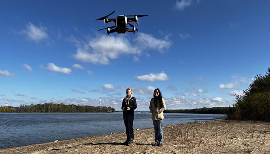
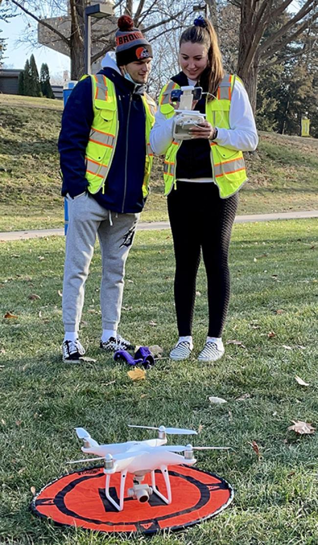
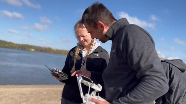
She had spent hours piloting drones and learning FAA test requirements in her Drone Mapping and GIS (geographic information system) class with Dr. Reuben Heine last fall. Walljasper and 10 other students, half of the class, went further by earning their certification through a testing site at a Quad-Cities airport.
Flying wasn’t the best part of the class for Walljasper. Their purpose was to use drones to create high-resolution aerial maps, and use the drone data in ArcGIS Pro software to create 3D images of campus buildings and sites through a process called photogrammetry. Augustana’s facilities services is using the final 3D renderings for planning and repairs.
That was the best part for her: “Seeing it all compiled together.”
“None of us had ever used photogrammetry, none of us had really ever flown drones before, so we just got right into learning it,” Walljasper said.
Dr. Heine, the Edward Hamming Chair of the geography department, knows students get excited just seeing the class title. Alongside the general thrill, for geography students there’s eagerness to use this new field tool.
“Then there is that moment when they really come to understand what they’re getting with drones," he said.
The difference between the best satellite imagery and drone imagery, he said, is “the difference between looking at a Minecraft world that’s all pixelated and blocky, and the real world…. It’s hundreds of times better resolution than you can get with existing mapping products.”
He pointed out that with drones you can see detail on individual tree leaves, or individual bolts on campus buildings.
Along with higher resolution, drones provide a truly new perspective. Geographers have always conducted their analyses on the ground level, based on what they see with their own eyes — and also using maps, from the global scale on down. “But even the best maps only take you down so far,” Dr. Heine said.
Between ground-based and aerial perspective is another one, “just above head level, that informs our understanding of the world around us,” he said. “What’s so exciting with drones is that it puts you in control of that in-between.”
As soon as he shares that with students, he said, “they see it.”
So does Augustana’s facilities department.
What more access to ‘the real world’ can do
The class was divided into groups, each in charge of mapping a section of campus. Once they learned how to safely maneuver the drone, the groups planned their flights and captured more than 1,400 images.
Then, working with Director of Facilities Bob Lanzerotti, the students created an aerial base map of campus. They also designed new geodatabases of 3D renderings of building roofs and surfaces such as athletic fields and parking lots.
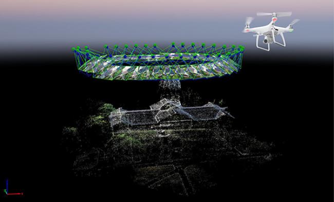
To do this, they used a process called photogrammetry to resolve photos in 3D. Because only the center of a photo is distortion-free, Dr. Heine explained, photogrammetry overlays images so that measurements can be made using only those distortion-free sections (see Old Main image).
Students can “take lots and lots of photos and deliberately assemble them into a final digital product that’s then usable in GIS,” said Dr. Heine. He describes photogrammetry as “the in-between of drone flying and GIS.”
This spring, four students are continuing their class final database project through paid internships with Augustana's facilities department. Two are working with the grounds crew to focus on paved, grassed and forested areas, prioritizing pollinator gardens and sites that need attention, and later, permeable paved surfaces.
Amanda Walljasper is one of the two interns working on a rooftop geodatabase. Building on the drone data from the class mapping project, the interns are adding measurements, roof types, angle and pitch, make and model, etc., so that facilities will have a database about the state of a rooftop.
And in the future, the facilities department will hire a student worker with GIS background to keep the project going.
Precision agriculture and other futures for the field
Walljasper’s minor in geographic information science and technology (GIST) supports her majors in public health and environmental studies. She said what drew her to GIS is “all the possibilities, and that it’s constantly growing.”
Inspired by both the human/social and physical/environmental sides of public health, she knows GIS can influence her future career, though she doesn’t yet know how. “I want to make positive changes for both the environment and for people, and keeping the environment healthy keeps people healthy.
“I really like research and interacting with people — and going out into the field, too," she said. "I like it all, which makes it hard to narrow it down.”
Walljasper has plenty of time to find her path — and a great resource in Augustana’s CORE (Careers, Opportunities, Research, Exploration). That’s where she found her major interests, with the help of her vocational exploration advisor, when she realized she no longer wanted to be the band director she’d imagined in high school.
“The drone industry is on the cusp of exploding, so I am excited to be on the leading edge of the industry.”
– Ben Ford ’22
Senior Ben Ford, with his GIST minor and majors in geography and business administration, knows exactly how he’ll use his GIS and drone skills after graduation: as a UAS Flight Operations intern for a precision agriculture company called Sentera.
Ford will travel “to farm fields across eastern Iowa and western Illinois to collect various types of data with Sentera’s FieldAgent technology,” he said. He’ll be “giving farmers accurate insights regarding crop stand counts, tassel counts, crop health, yield estimates and precision weed mapping, to name a few.
“So, basically, I will be the one flying the drone and collecting the data, then sending this data off to analysts at Sentera to create useful deliverable data for farmers who want to know more about their cropland.”
When he was introduced to drone technology through his GIST minor, he saw the powerful data it could offer.
“And that led me to seek a job position that uses drones to help others,” Ford said. “The drone industry is on the cusp of exploding, so I am excited to be on the leading edge of the industry.”